
林火并非全然是灾难,它是塑造生态的关键力量。云南藏着数百万年的古老草地生物群落,却因认知偏差被误判、遭破坏,保护占比远低于森林。重新认识林火的生态价值,守护这片被忽视的生物多样性宝库,已刻不容缓…
出品:格致论道讲坛
以下内容为中国科学院西双版纳热带植物园研究员Kyle W. Tomlinson演讲实录:
大家下午好。
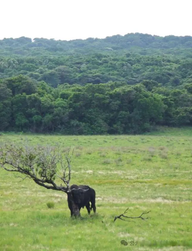
我出生在南非,在那里长大,成长的地方靠近圣卢西亚湖。
森林与草地镶嵌共存
下面是一些我家乡的照片。这张照片是我拍的,它展示了当地的典型景观:前景是草地,背景是森林,它们紧挨在一起,相安无事,而且栖息着完全不同的物种。它们是两种非常不同的生物群落。
这张照片展示了这种植被的拼贴状结构,箭头指向的是我上一幅照片拍摄的地方。从画面上可以看到,森林和草地交织在一起,森林呈深绿色,草地则有两种色调——黄色和浅绿色。这是因为这里存在林火。
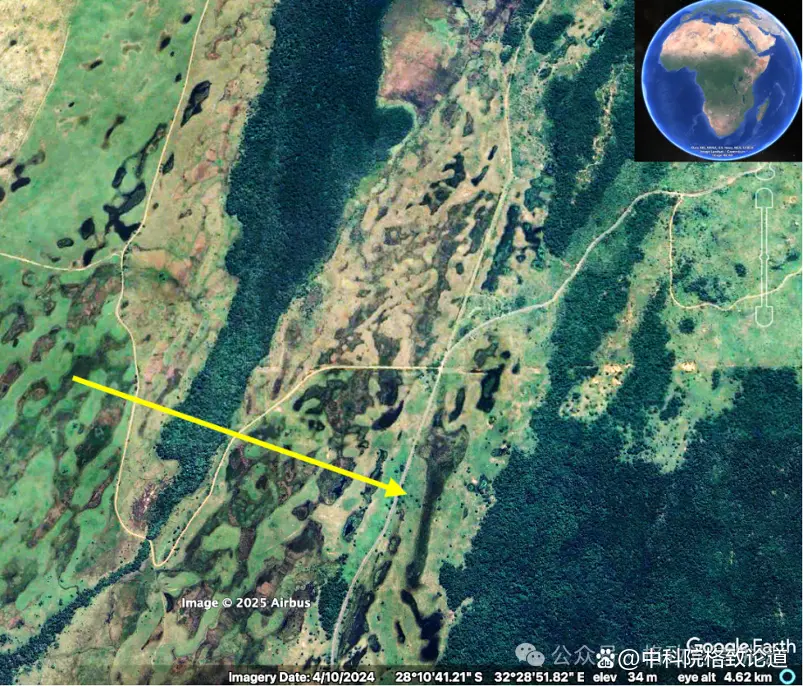
林火维持着这种森林与草地并存的景观。草地的颜色代表了距离上一次林火的时间。如果是浅绿色,意味着林火发生的时间比较近;如果是黄色,则说明林火发生在更久以前。这片植被可以完全是森林,但因为有林火这个干扰项,才形成了森林与草地镶嵌共存的格局。
我再多介绍一下这两种生物群落:森林生物群落和草地生物群落。
森林生物群落通常有非常封闭的树冠层,这意味着很少有光线能穿透到林下,地表层的植物通常有宽大的叶子。而在草地生物群落中,树冠层则较为开阔,有更多光线能够到达地面,林下层以草类植物为主,草地生物群落的名字也因此而来。
▲左:森林生物群落
右:草地生物群落
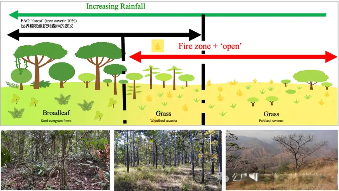
我们所说的草地生物群落涵盖了一系列景观,从完全开阔的草地到树木零星分布的公园式草地,再到树木较多但仍有大量光线透入林下的疏林草原,都属于草地生物群落。因为它们的林下以草类为基础,因此与森林有本质区别。
而这里存在一个问题。目前许多国家遵循的是联合国粮农组织(FAO)对森林的定义,即树冠覆盖率大于10%的区域就是森林。但根据我们现在的理解,这是不准确的。
草地生物群落与森林之间真正的过渡点大约在50%到70%的树冠覆盖率之间,这意味着中间这部分区域目前被归类为某种森林,并按照森林来管理。但实际上,它们是由林火决定的,也应借助林火进行管理,并且被以完全不同的视角看待。
下面我将进一步谈谈草地生物群落中的两种主要干扰因素:林火和哺乳动物食草行为。
林火通常发生在湿季与干季分明的环境中,因为植物在雨季会大量生长,而在旱季会变得干燥。如果是草,它们会变得非常干燥,足以维持林火的燃烧。
哺乳动物的食草行为通常发生在更干旱的环境或者土壤非常肥沃的地区。因为哺乳动物对食物的营养(密度)有最低要求,而只有在非常干旱或者土壤非常肥沃的条件下,食物的营养(密度)才足以支撑大规模的食草行为。
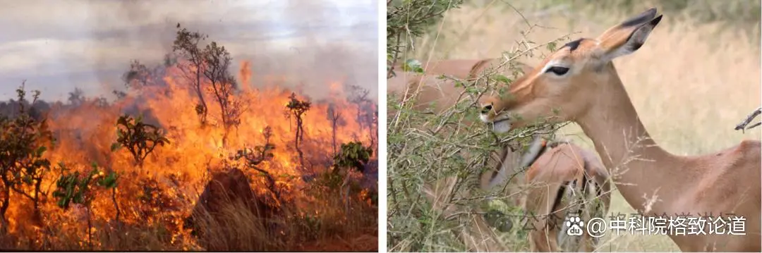
▲左:林火,© William Hoffmann
右:哺乳动物的食草行为,© Ninya Quibod
这两种干扰发生的环境不同,对植物的选择也不同,因为它们影响植物的方式很不一样。林火是大规模事件,它会横扫整个区域,清除所有死亡的生物量以及部分活体生物量。
植物演化出了特定的应对方式,它们倾向于将生物量储存在地下,并将芽点靠近地表。这意味着当林火发生时,大部分生物量是受到保护的,芽点也受到了保护,因此它们能在林火后迅速重新生长。而这些环境中的木本植物往往有很厚的树皮,这意味着它们可以免受林火带来的高温伤害。
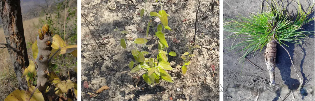
▲左:厚树皮
中:贴地生长的新芽
右:块茎
哺乳动物食草行为的作用方式则非常不同。动物来了,吃掉植物的一小部分,然后离开。但第二天,它可能又会来,重复这种小规模的生物量消耗。
因此,在以哺乳动物为主的区域中,植物演化出了一套完全不同的特征。它们往往分枝很高,并且长有尖刺,这些特征使动物很难够到可食用的部分,尤其是在有尖刺的情况下,因为尖刺会刺痛它们。
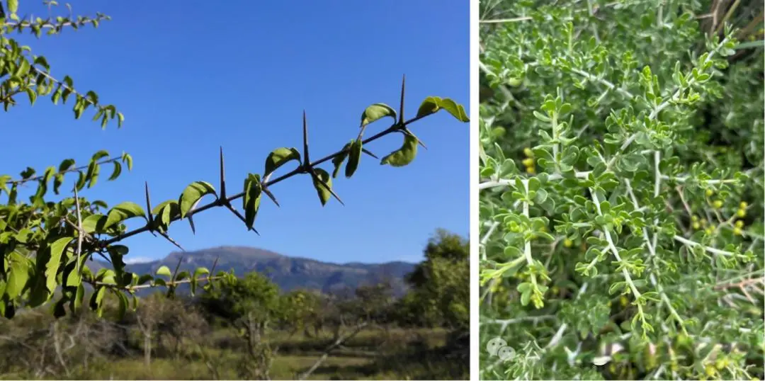
▲左:尖刺
右:复杂分枝
这两种不同的干扰实际上选择了完全不同的生命形式,也为物种演化创造了条件。因此,世界各地草地生物群落中的成千上万个物种,它们要么适应了火,要么适应了哺乳动物的食草行为。
解答四个问题
已完成:50% //////////
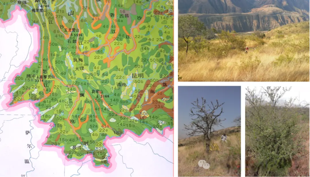
现在说说我来到中国的故事。2013年,我移居中国,在云南省(黄圈)的西双版纳热带植物园任职(黄点处)。我想大多数人都知道,云南是中国生物多样性皇冠上的明珠,它拥有中国50%的植物物种,物种非常丰富。这与云南的地理位置有关。
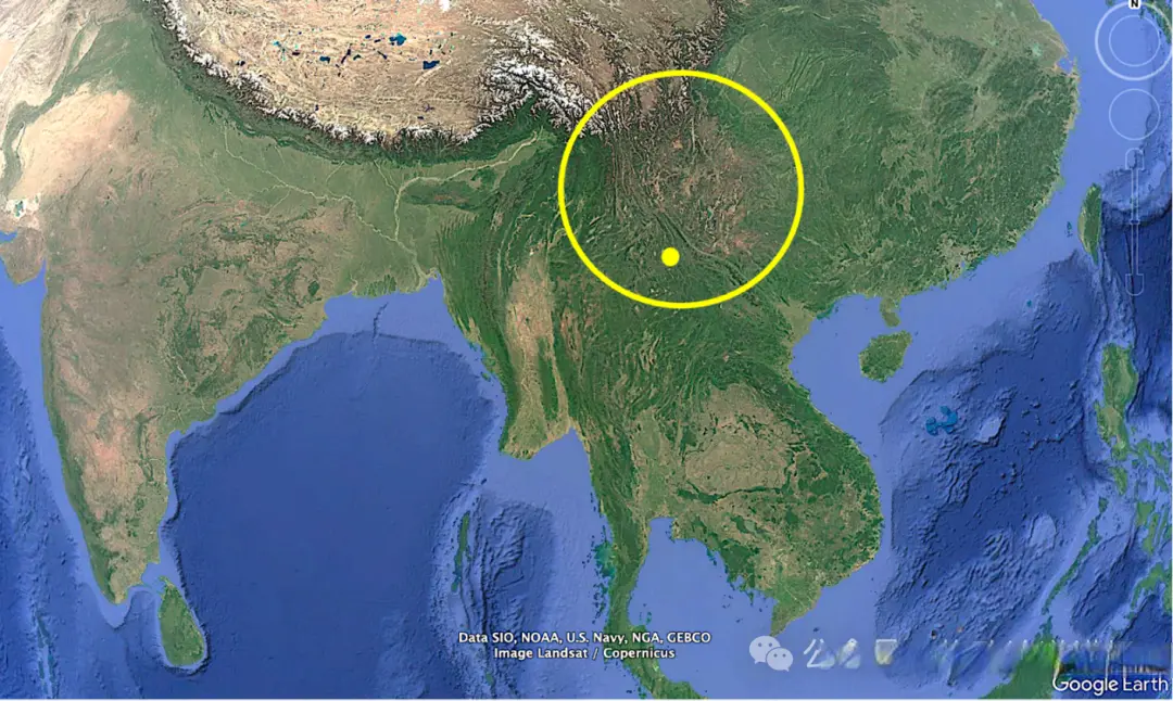
云南位于两种季风气候之间,分别是来自东海的东亚季风和来自孟加拉湾的南亚季风。此外,云南还有非常多的山,所以拥有非常多样的环境条件,这解释了它的生物多样性为何如此丰富。
大家注意看上图里的颜色。你可以在巴基斯坦最西部和青藏高原区域看到一些非常浅的颜色,那是沙漠的信号,是非常干旱的生态系统。你也能看到深绿色,那是森林。你还能看到其他颜色,比如卡其色和浅绿色,它们代表农业用地或者某种草地生态系统。如果你观察圆圈的内部,会发现既有深绿色也有卡其色,这说明在云南既有森林生态系统,也有草地生态系统。
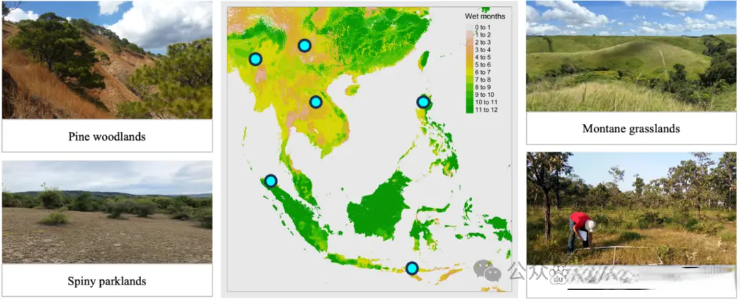
我刚到中国时,手头的植被地图是这样的(下图左)。在这张我截取出来的云南省植被地图(2001)中,只有一种草地生物群落被识别出来了,那就是干热河谷稀树草原(橙色线条标记处)。它通常分布在云南呈南北走向的河谷地带。这种群落非常典型,具有非常开阔的公园式草地的特征,也表现出了对林火和食草动物的形态适应。
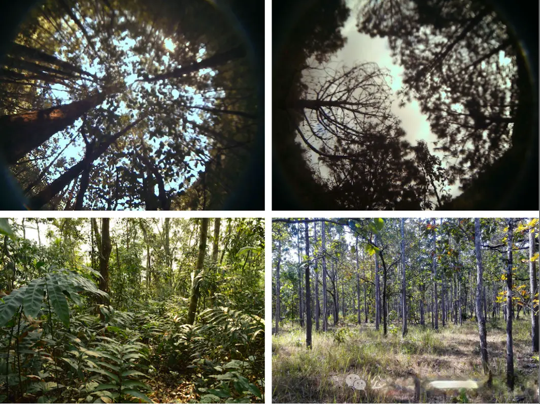
还有另一种有趣的植被类型,也就是上图中的浅绿色区域。在这张植被地图里,浅绿色被称为松林。为了了解实际情况,我走访了云南各地,想亲眼看看植被的样子。当我走访到这些浅绿色的地区时,遇到的景象经常是下图这样的。
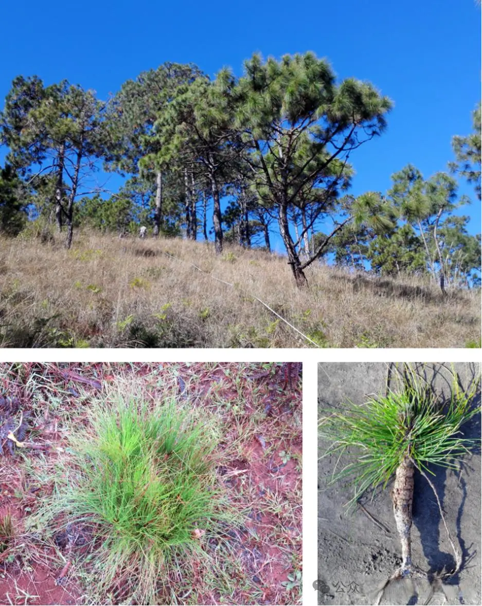
这的确是一片松林景观,但它非常开阔,而且林下以草类为主。至于松树本身,它们在幼苗阶段就把很多生物量储存在地下,甚至还拥有一个我们称之为“草状期”的阶段,这是一种对火的形态适应。我们在美国东部也发现了这种情况,这在松林稀树草原中非常典型。
对我来说,问题是:我们眼前的真的是森林吗,还是某种草地生物群落?
在思考这一切的同时,我受邀撰写一篇综述论文,内容是稀树草原,一种亚洲热带的草地生物群落。一起的还有两位来自印度的同事。
我们认为有四个非常重要的问题。第一,是否存在适合草地生物群落的气候空间;第二,这些草地生物群落有多古老;第三,这些植物是否具有对林火和哺乳动物食草的形态适应,是否适应了干旱和光照条件;第四,这些草地生物群落在哪里,分布有多广泛,它们的保护现状如何。
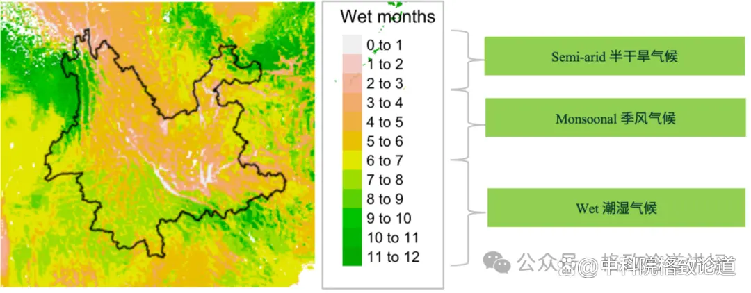
随后,我把这四个问题应用到了云南的研究上。这是第一个问题:气候。下图显示了云南和周边地区每年湿润的月份数,深绿色表示这个区域一年中大部分时候都是湿润的。橙色区域是季风气候,意味着有几个月份非常湿润,有几个月份非常干旱,这是可能发生林火的条件。还有一些白色区域是半干旱区域,一年中大部分时间都非常干燥,这可能表明有某种适合食草动物的区域。至少从气候空间来看,这里可能有稀树草原。
接下来,可能是我们做的最重要的工作:我们试图了解这些草地的年龄。为此,我们使用了两种草种——黄茅和黄背草。
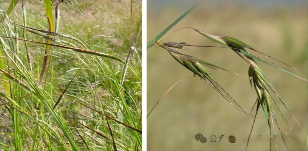
▲左:黄茅 Heteropogon contortus
右:黄背草 Themeda triandra
之所以选择这两种草,是因为黄茅适应了哺乳动物的食草行为。它的种子非常尖锐,会刺入你的皮肤,这也是它为什么得以传播。而黄背草则对林火高度适应。南非的长期实验表明,在林火高频发生的环境中,它会成为优势物种。
这两种植物在云南广泛分布。为了获得可靠的种群分析样本,我们在整个区域内进行了采样。我们对重建这些物种的系统发育时间树很感兴趣,并想通过这个时间树估算两件事——这些草地在云南境内存在的时间,以及我们是否能在河谷群落和河谷之外的群落中都找到它们。
河谷群落是被识别的草地生物群落,但河谷之外的山地区域,过去一直被当作是某种森林。
我们确实找到了支撑这两点的证据。首先是这些草地的年龄,它们已经在云南至少存在一百万年了,这仅仅是我们所研究的这两个物种给出的数据。
另一个重要的发现是,我们找到了两个主要的亚支系:蓝色支系和黄色支系。黄色支系分布在河谷地区,而蓝色支系分布在山地地区,它们在一百万年前就分化了。这意味着我们拥有分别适应河谷和山地环境的种群,说明这些草地非常古老。更重要的是,它们远在人类学会用火来改变地貌之前就存在了。
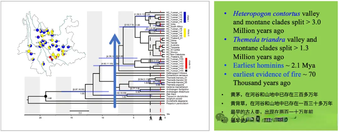
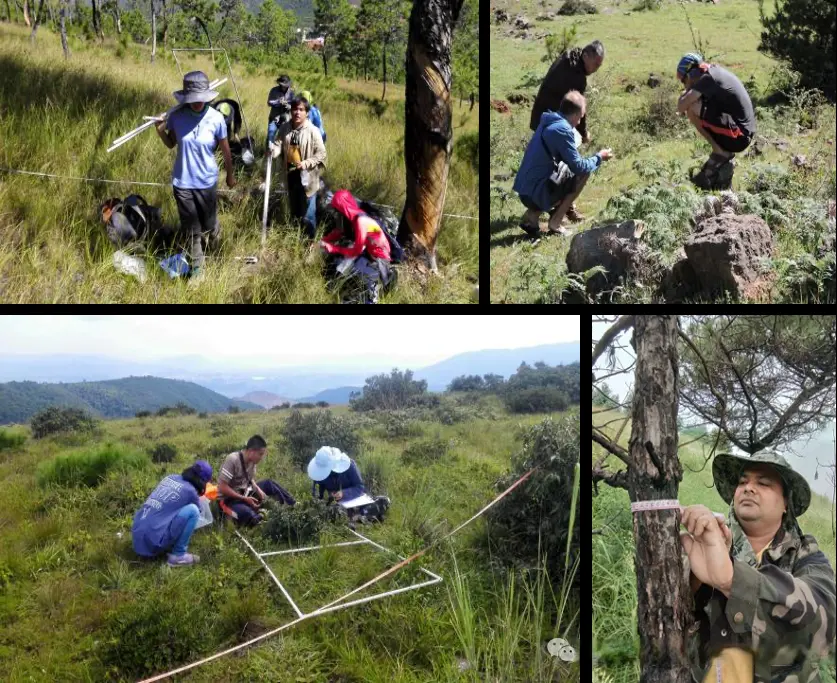
我们尝试做的另一件事是了解这些草地的多样性。为此,我们实地调查并采集了遍布云南的数十个样方。我们完成的数量不算多,一共 54 个,但这是非常艰苦的工作,需要整整一天才能完成一个样方的调查。最终,我们的采样范围覆盖了云南中部,但西部和东北部仍有空白,需要进一步采样。
分析这些数据时,我们再次发现了相同的规律。下图的红点代表河谷群落,蓝点代表山地群落,两者并不一样。我们总共发现了大约800个物种,这表明这些群落的物种丰富度非常高,其中包含大量草本物种,而且它们在群落中占据主导地位。
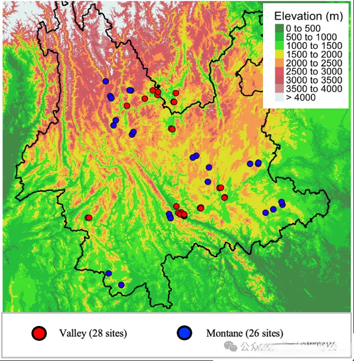
更重要的是,蓝点山地群落的生物多样性是高于河谷群落的,也就是说山地地区物种丰富度高于河谷地区。
综上所述,云南草地生物群落的实际分布范围远比植被图上显示的要广泛得多,这促使我们重新去评估这些包含草本植物的山地植被。
接下来,我们想了解草地生物群落在云南的分布面积。我们使用的方法是遥感,测绘了不同类型的植被以及人类的土地利用类型。在植被方面,我们重点关注三类,一是森林(绿色);二是疏林草地(橙色),一种树木比较密的草地生物群落;三是公园式草地(黄色),一种树木分布非常稀疏的草地生物群落。
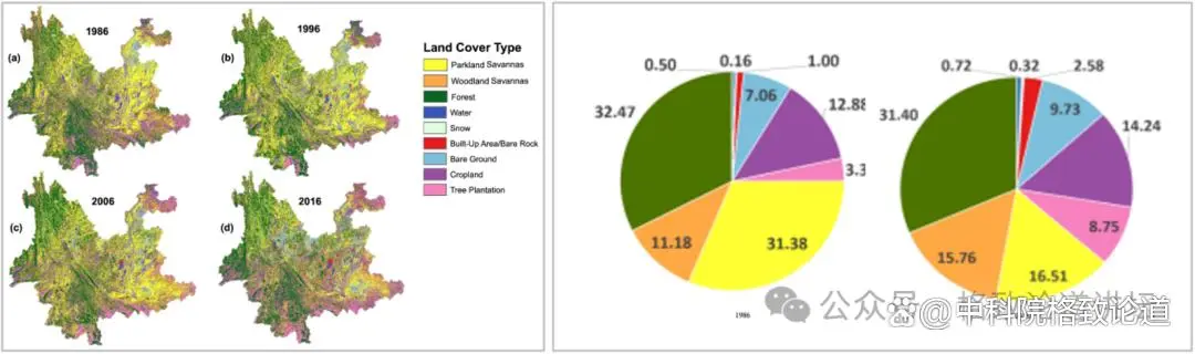
▲1986到2016的云南植被变化
基于现有的卫星影像,1986年是我们能追溯到的最早时间,2016年则是我们最后一次查看的时间。在1986年,云南有超过40%的面积都是某种类型的草地生物群落,但到了2016年,其中20%的面积已经消失了。与此同时,森林面积则没有太大的变化。所以,云南受到人类活动和开发影响最严重的区域,其实是草地生物群落。
此外,我们还尝试通过分析找出这段时期中保持完整的草地生物群落分布地,以及它们与云南现有的保护区范围(下图粉色线条)是否匹配。
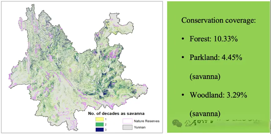
在云南东部,分布着大片三十年中保持稳定的稀树草原(上图深蓝色区域),而整个云南北部地区,至今保留着许多草地生物群落。我们希望这张地图能够帮助保护规划者建立自然保护区,保护这些草地生物群落。因为目前云南仅有约4.5%的草地生物群落得到了保护,而森林的保护比例则达到了10%。可以说,草地群落并没有得到它们应有的关注。
管理与保护
已完成:90% //////////
我们已经知道草地生物群落分布广泛,下一个问题是,我们该如何管理这些生态系统?
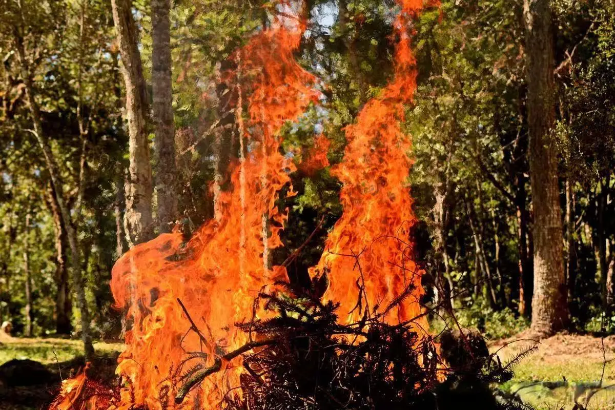
我之前提到过,干扰事件至关重要。但问题在于干扰的程度、干扰的频率以及具体的操作方式。我们需要考虑哺乳动物食草和林火这两种类型。目前,我们已经开始研究食草行为的影响,林火的研究则之后再做,因为林火在东亚是一个争议很大的话题。
在中国,甚至在东南亚,人们都非常反对使用林火。这是有道理的,因为林火非常危险。在其他大洲,林火曾经同样被认为有害无益。但林火是必不可少的,美国就是一个例子。
美国曾经长期实行禁火的政策,但最终意识到,林火对于维持特定生态系统至关重要。我相信,随着证据的不断积累,亚洲最终也会发生同样的转变,政策制定者们会逐渐意识到,我们需要把林火视为一种管理工具,引入到生态系统的管理中。
与此同时,我们已经将这项研究扩展到了整个东南亚。通过下图,可以看到同样的湿润月份分布图,也可以看到季风气候广泛分布于中南半岛以及印度尼西亚。我常常前往这些地区进行采样,并发现了几种不同的草地群落,其中一些适应了林火,另一些则明显适应了哺乳动物的食草行为。
这是一个广阔的、需要研究的区域,它目前仍然在被当作森林对待,但令人欣慰的是,已经有一大批研究者开始对这项工作产生兴趣。我们成立了一个名为热带东亚稀树草原网络的团队,团队成员们正在研究草地生物群落的生物多样性、历史、范围、变迁以及林火。一些研究者还在研究人们在不同植被中如何利用林火,并开展实验以了解林火未来将如何影响植被。
总之,我的工作表明,在云南存在着广泛分布的草地生物群落,范围比我们之前认为的要大得多。它们很古老,已经在这里存在了数百万年,但目前正在迅速变化。
我希望我们在中国和东南亚的工作,能提高政策制定者对保护这一生态系统的关注度,并最终促进对热带东亚地区草地生物群落的保护。
谢谢大家!
Grassy Biomes:Life Through Flames And Teeth
Good afternoon.
So I was born in South Africa, as you were told, I grew up there, and I grew up near a place called Lakes Saint Lucia. Here are some images from that location.
I took the photo on the left hand side and it shows you the typical landscape. There are grasslands in the foreground and there are forests in the background. Right next to each other, no problem. And they house completely different species.
They are two very different types of biomes. The image on the right hand side shows the patchwork of this landscape, and the arrow points out where I took that photograph. What you can see is that there are forests and grasslands mixed together. The forests are dark green and the grasslands are in two shades. They are in yellows and pale greens
And that's because there is another process that's very important here which is fire. Fire is maintaining this landscape of forests and grasslands side by side. The colors in the grasslands represent the times since the last fire. if it's pale green, that means the fire was more recent, and if it's more yellow, that means the fire happened further back in time.
So importantly, this landscape could all be forest but because of fire, a disturbance event. It is actually a mosaic of grasslands and forests.
Now a little bit more about these two biomes. We have forest biomes and grassy biomes. Forest biomes typically have a very closed canopy of trees. That means there's very little light penetration into the understory. The ground layer plants typically have broad leaves. In grassy biomes the forest canopy is more open and more light penetrates to the ground. Because of that the understory is dominated by grasses hence the name grassy biomes.
This is where it gets interesting, because what we call grassy biomes is a range of landscapes from completely open grasslands to parklands where you would see a few trees to a vegetation which has got a lot of trees in it. But still there's much light penetration into the understory we call these woodlands, and they still form part of the grassy biomes because they're underlain by grasses, and so they are distinct from forests.
There's a bit of a problem here because presently many countries follow the definition given by the FAO for forests. And that says any area with a canopy cover of greater than 10% is a forest. But actually, according to our modern understanding, this is not true. The true transition between grassy biomes and forests is somewhere between 50 and 70%, that means that this area in the middle which is presently being classified as some kind of forest, is being managed as a forest. But actually it is dependent on fire and should be managed with fire, viewed completely differently.
I'm going to talk a little bit more about two major disturbances that we find in grassy biomes: fire and mammalian herbivory. Fire is typically found in environments where we have strong wet and dry seasons. And the reason for this is that the wet season is a lot of plant growth, and in the dry season that plant material starts to dry out. If it's grass, it becomes very dry and can sustain fires.
Mammalian herbivory is typically more common in more arid environments or over very fertile soils. The reason for that is that mammals have a certain minimum requirement for nutrition in their food, and only under very dry conditions or very fertile soil conditions is the plant material sufficiently good that you can get large amounts of mammal herbivory.
That means that these two disturbances occupy quite different environments, and they are selecting for different plant species, and the reason for that is that the way the disturbances affect plants are quite different. Fires are really large events, they will clear out the whole landscape removing all of the dead biomass and some of the living biomass as well.
Plants have evolved particular ways of coping with this. They tend to store biomass underground and they keep their buds close to the surface. That means when the fire goes through, a lot of the biomass is protected and their buds are protected, so they can reshoot rapidly after a fire event. Woody plants in these environments tend to have very thick bark. That means that they are insulated from the heat damage that is associated with fires.
Herbivory is very different in the way it functions. An animal comes, eats a little bit of the plant, and moves on. But the next day, it may come again and repeat these small amounts of biomass removal.
So plants in mammal-dominated landscapes have evolved a completely different set of characteristics. They tend to have very high branching and they often have spines. These things make it difficult for animals to reach the palatable parts to eat, dissuade them from eating, especially if there's spines because they are painful.
So the takeaway message here is that these two different disturbances are actually selecting for completely different life forms. They are actually generating the conditions for species to evolve. And so in grassy biomes around the world there are literally thousands of species, tens of thousands of species adapted either to fire or to herbivory.
Now we get to the part where I came to China In 2013. I moved to China and took up a position at Xishuangbanna Tropical Botanical Garden which is located in the dot. It's in Yunnan province, which here I've just indicated with the Yellow Circle. Yunnan is the crown jewel of the biodiversity of China. It houses 50% of the plant species in China, so it is really species rich, and that's to do with its location.
It's actually situated between two monsoonal types, the east monsoon coming from the East China Sea and the southern monsoon coming from the Bay of Bengal. In addition, Yunnan is extremely mountainous so it has a really wide array of environmental conditions. That explains the diversity.
Now the next thing I want you to notice is the colors in this image. You can see very pale colors in the far west in Pakistan and on the Tibetan Plateau. And that is a signal of desert very arid ecosystems. You can see dark greens, those forests. Then you see these other colors, khakis and pale greens, and they represent areas where we have either agricultural lands or some kind of grassy ecosystem.If you look inside the circle, you can see that we have both dark greens and khaki colors. That indicates that in Yunnan we have both forest ecosystems and grassy ecosystems.
Now when I arrived in China, this was the vegetation map that was available. In the vegetation map for Yunnan which I cut out here there was only one recognized type of grassy biome, that was the dry valley savanna. It's indicated by these orange lines, that often moving north and south along the river valleys in Yunnan, and it's very typical. It has very open parkland type but it also shows morphological adaptations both for fire and for herbivory. So it seems that both of these drivers are important at least in this type of vegetation.
But there's another type of vegetation that's interesting here, the pale greens. Pale greens are known as pine forests on this vegetation map. I traveled around Yunnan to see what the vegetation looks like because I need to get some feel for what is going on. When I visited these areas, I often encountered this.
It's a pine landscape, but it's very open and the understory is dominated by grasses. And the pines themselves, the juvenile stage shows a lot of storage underground and it even has this thing we call the grassy stage. This is a morphological adaptation for fire. We find it also in the eastern United States. It's very typical of pine savannas. So the question for me was: are we really looking at forests or are we looking at some kind of grassy biome?
At about the same time as I was thinking about all of this. I was asked to write a review on what was known about savannas a type of grassy biome across tropical Asia, together with two colleagues from India.
We decided that there were four very important questions to ask. Firstly, is there a climate space suitable for grassy biomes? Secondly, how old are the grassy biomes? Third, if we look at these plants, do they have morphological adaptations for fire, for herbivory, and are they adapted to dry and light conditions? And fourth, where are these grassy biomes? How extensive are they and what is their conservation states?
I'm not going to talk about that paper, but subsequently, I applied these four questions to Yunnan. So this is the first problem: the climate. And this is showing you the number of wet months per year across the region around Yunnan. The outline of Yunnan is given here. Where it's dark green that means it's wet most of the year. Where it's orange that's a monsoon climate that means that several months are very wet and several months are very dry, those are the conditions where we can get fire. There are also some white areas. These are semi-arid landscapes where it's very dry most of the year, and that might indicate that we actually have some kind of landscape suitable for mammalian herbivores. So the climate space says we probably could have savannas here.
The next thing and maybe this was the most important work we did is we tried to understand the age of these landscapes. To do that we used two grass species: Heteropogon contortus and Themeda triandra.
The reason we chose these two species is because Heteropogon contortus is adapted to mammalian herbivory. It has very sharp seeds that stab into your skin, and that's how it gets transported around the landscape. Themeda triandra is very adapted to fire. There have been long-term experiments in South Africa that show it dominates under high fire frequencies.
Both these species are widely distributed across Yunnan. We sampled across the whole area to get a good sample for the population analysis. What we were interested in is reconstructing a time tree of the phylogeny of these species. With that time tree we wanted to estimate two things, what is the age of the species inside Yunnan and whether we found evidence for both a valley community and a community outside the valleys.
Remember the valley community was recognized but the outside area—the mountain area was considered some kind of forest.
And what we did find evidence for both these things. Firstly, the age of these grasslands they appear to have been grasslands across Yunnan for at least a million years. That's just the species we've used.
But the other part of this which is very important is that we found two major subclades, the blue clade and the yellow clade. The yellow clade was found in the valleys, and the blue clade was found in the montane areas. They split a million years ago. So that means that we have populations ecotypes—associated with the valleys and with the mountain areas, suggesting these grasslands are very old. Importantly, that dates them long before the time when humans first manipulated this landscape using fire.
The other thing we tried to do is understand the diversity of these grasslands, so we went out and we sampled several plots across Yunnan. We didn't get that many done, we got 54 done but it's very hard work, it takes a full day to complete one plot. In the end, we got the spread across the middle of Yunnan, but we're missing areas in the west and in the northeast that still need to be sampled.
When we did this, again we found the same pattern. We found a valley community in red and a mountain community in blue and they were different. In total we found about 800 species that indicated, that actually we have quite high species of richness in these communities and there were a high number of grass species, and they dominated these communities.
And importantly, the blues the mountains they were more diverse than the valleys, so more of the species richness in these grasslands was found in the mountain areas than in the valley areas than in the valley areas.
So together this information indicates that actually in Yunnan, grassy biomes have been much more widely distributed than indicated in the vegetation map. And they call for reassessment of these mountain landscapes containing plants.
The next thing we wanted to understand is how extensive are these grassy biomes across Yunnan. We used a remote sensing method to do this. We mapped different types of vegetation and different types of land uses by man. For the vegetation we were interested in three groups: forests in green; woodlands, a type of grassy biome with dense trees in orange; and parklands, another type of grassy biome with very widely dispersed trees in yellow.
And if you look at the maps, 1986 was the earliest we could do, based on available satellite imagery, and 2016 was the last time period we checked. In 1986, more than 40% of the landscape of Yunnan was some kind of grassy biome vegetation. But by 2016, 20% of that area had been lost. Over the same period, the forest area didn't change much. So the area that seems to be the most affected by human activities and developments in Yunnan was actually the grassy biomes.
The other thing we tried to do with this analysis was to understand where grassy biomes had remained intact over this period of our analysis, and how that matched with the present conservation estate in Yunnan indicated by the pink lines.
So the dark blue areas they indicate where the savanna has remained stable over the three decades. You can see that in eastern Yunnan, there's actually a lot of this area, but actually across the whole of northern Yunnan there are many areas that contain grassy biomes to date. We hope that this map will help inform conservation planners to develop nature reserves to protect grassy biomes. Because at present only about 4.5% of grassy biomes are protected in Yunnan whereas 10% of forests are protected. So this type of vegetation is receiving less interest than it deserves.
So even that picture of the fact that there are actually a wide distribution of grassy biomes, the next question is: how should we manage these ecosystems?
I told you already that disturbance is critical, but the issue is how much disturbance, how frequently and how do we do this. We need to think about the two types, we need to think about herbivory, it might be important and we need to think about fire.
We started working on herbivory, and we're gonna do fire later because fire is very controversial in East Asia, not just in China but also in Southeast Asia, people are very opposed to using fire with good reason. It's very dangerous, but it's been shown on other continents where previously fire was seen as a bad thing that fire was necessary. The United States is an example. They used to have a policy where they refuse to use fire, but they recognize eventually the fire was important for maintaining certain ecosystems. And I believe the same thing will happen in Asia eventually. As evidence accumulates, policymakers will come to see that we need to use fire as an agent in managing these ecosystems.
At the same time, we've now expanded this research across the whole of Southeast Asia. Here you can see the same wet months map, and you can see that there is a monsoon Southeast Asia and also in Indonesia. Southeast Asia and also in Indonesia I've been traveling to these areas doing some sampling, and we have found several different grassland communities, some are adapted to fire and some are clearly adapted to mammalian herbivory.
There is a huge area that needs research that presently is being treated as forest. Thankfully now there are actually a whole bunch of researchers that have got interested in doing this work. We started a new group which is called the Tropical East Asia Savanna Network. This group of people are studying the biodiversity, History, the extent changes of these grassy biomes and also fire. There are several researchers looking at how people have used fire in different landscapes, and also setting up experiments to understand how fire affects the vegetation into the future.
So in summary, what my work has shown is that in Yunnan at least there is an extensive grassy biome vegetation much wider than was previously thought. And It's old, it's been here for millions of years but it's changing very rapidly.
I hope that the work that we're doing both in China and also in Southeast Asia is going to elevate interest from policymakers in protecting this ecosystem, and that this work will lead to greater conservation for grassy biomes across tropical East Asia.
Thank you.
“格致论道”,原称“SELF格致论道”,致力于非凡思想的跨界传播,旨在以“格物致知”的精神探讨科技、教育、生活、未来的发展,由中国科学院计算机网络信息中心和中国科学院网络安全与信息化办公室主办,中国科普博览(中国科学院科普云平台)提供技术支持。
 晋ICP备17002471号-6

 分享给我的好友